Nachrodt-Wiblingwerde
Nachrodt-Wiblingwerde | |
|---|---|
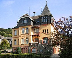
 Old town hall (Amtshaus) | |
Location of Nachrodt-Wiblingwerde within Märkischer Kreis district  | |
| Coordinates: 51°19′N 07°39′E / 51.317°N 7.650°E | |
| Country | Germany |
| State | North Rhine-Westphalia |
| Admin. region | Arnsberg |
| District | Märkischer Kreis |
| Subdivisions | 7 |
| Government | |
| • Mayor (2018–23) | Birgit Tupat[1] (Ind.) |
| Area | |
• Total | 29.01 km2 (11.20 sq mi) |
| Elevation | 305 m (1,001 ft) |
| Population (2023-12-31)[2] | |
• Total | 6,418 |
| • Density | 220/km2 (570/sq mi) |
| Time zone | UTC+01:00 (CET) |
| • Summer (DST) | UTC+02:00 (CEST) |
| Postal codes | 58769 |
| Dialling codes | 02352 u. 02334 |
| Vehicle registration | MK |
| Website | www.nachrodt-wiblingwerde.de |
Nachrodt-Wiblingwerde is a municipality in the Märkischer Kreis, North Rhine-Westphalia, Germany.
Geography
[edit]The municipality is split into two main settlements. Nachrodt is located in the valley of the river Lenne at an altitude of 140 m above sea level, while Wiblingwerde is located at an altitude of 480 m on the hills of the Lennegebirge, one of the hill chains in the Sauerland mountains.
Division of the municipality
[edit]
|
|
History
[edit]The municipality was formed in 1907, when the Amt Altena was dissolved. The two municipalities Kelleramt and Wiblingwerde were merged into the new municipality Nachrodt-Wiblingwerde, which was no longer member in an Amt anymore.
Coat of arms
[edit]The coat of arms of the municipality shows in the top part the red and silver rose from the church seal of the Kirchspiel Wiblingwerde. In the bottom is a wavy line representing the river Lenne and thus Nachrodt. Both symbols are separated by the red-and-silver chequered bar of the Mark. The coat of arms was designed by Otto Hupp, and was granted on October 17, 1935.
References
[edit]- ^ Bürgermeisterwahl Gemeinde Nachrodt-Wiblingwerde, accessed 21 June 2021.
- ^ "Bevölkerung der Gemeinden Nordrhein-Westfalens am 31. Dezember 2023 – Fortschreibung des Bevölkerungsstandes auf Basis des Zensus vom 9. Mai 2011" (in German). Landesbetrieb Information und Technik NRW. Retrieved 2024-06-20.
External links
[edit]![]() Media related to Nachrodt-Wiblingwerde at Wikimedia Commons
Media related to Nachrodt-Wiblingwerde at Wikimedia Commons
- Official site (in German)
- Tourist information (in German)


